March |
April |
|
| Sun. 3 Mar. 3:30 p.m. Birding tour. Meet at bridge over Riverside Canal. | Sat. 20 Apr. 8 a.m. Community Workday. Meet at bridge over Riverside Canal. | |
| Sat. 16 Mar. 9 a.m. Introductory tour. Meet at bridge over Riverside Canal. | Sun. 21 Apr. 5 p.m. Introductory tour. Meet at bridge over Riverside Canal. | |
| Sat. 23 Mar. 9 a.m. Community Workday. Meet at bridge over Riverside Canal. | Wed. 24 Apr. 6:30 p.m. Friends of the Rio Bosque meeting. 206 Kelly Hall, UTEP campus. | |
| Wed. 27 Mar. 6:30 p.m. Friends of the Rio Bosque meeting. 206 Kelly Hall, UTEP campus. | Sat. 27 Apr. 8 a.m. Birding tour. Meet at bridge over Riverside Canal. |
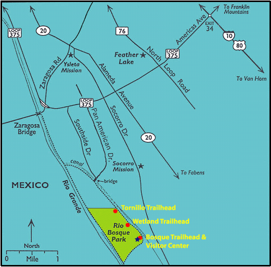
Hours: The park is open from dawn to dusk, 7 days a week.
Directions from I-10: Take the Americas Ave. (Loop 375) exit (Exit 34) and follow the interchange that merges with Loop 375 South. Take Loop 375 South to Exit 48A for Pan American Dr. Exit at 48A to the frontage road (Americas Ave.) and proceed to Pan American Dr., where you will turn left. After driving approximately 1.1 mile on Pan American, you'll cross a bridge over the Playa Drain. At 1.5 miles, you'll reach a second bridge, which crosses the Riverside Canal right before the gated entrance to the Jonathan Rogers and Roberto Bustamante water-treatment plants. If you are coming for one of the regularly scheduled tours, workdays or faunal-monitoring activities, the meeting place is at this bridge.
Directions from the César Chávez Border Highway (Loop 375 East): Exit at 47 to the frontage road (Americas Ave.) and proceed to Pan American Dr., where you will turn right. After driving approximately 1.1 mile on Pan American, you'll cross a bridge over the Playa Drain. At 1.5 miles, you'll reach a second bridge, which crosses the Riverside Canal right before the gated entrance to the Jonathan Rogers and Roberto Bustamante water-treatment plants. If you are coming for one of the regularly scheduled tours, workdays or faunal-monitoring activities, the meeting place is at this bridge.
To get to the Park itself, cross the bridge over the Riverside Canal, turn left onto the gravel levee road and proceed for about 0.75 miles. You'll be at the northeast corner of the park, at the Tornillo Trailhead. There are also two other trailheads farther down the levee road, the Wetland and Bosque trailheads. The Park's visitor center is at the Bosque Trailhead.
Navigation Note: Be careful when using a GPS navigation system to direct you to the park. Many systems direct you to 10716 Socorro Road, the park's designated street address. Unfortunately, at this time there is no access to the park from that location. You may have better luck entering the coordinates of the approximate center of the park, 31.640639, -106.309798.
Restrooms: The park's visitor center is not staffed. At this time, the 2 restrooms at the site are normally open only when scheduled groups are visiting the park.